Smailholm & Mellerstain
Introduction
Start & Finish – Car Park outside Smailholm Village Hall. .Smailholm is at the junction of the B6361 to Melrose with the B6397 (Kelso to Earlston). There is ample car parking at the village hall, which is situated on the north side of the B6361, some 150m from Smailholm Church.
Statistics
| DISTANCE | 14.3k |
| WALKING TIME | 3-4hrs |
| TERRAIN | Tarmac, grassy paths and fields (some boggy areas after rain) |
| RECOMMENDED FOOTWEAR | Walking Boots / Walking Shoes / Approach Shoes |
| REFRESHMENTS | No refreshments on this route |
Description
Stage 1
From the car park turn right for about 25m, then left up a tarmac road (signposted Smailholm Tower). Note on the right is the village pond and wildlife area.
Follow the road for 2.4km before turning right signed to Smailholm Tower. Please take care as the route now passes through a working farm and there may be moving vehicles or livestock. Follow signs for the Tower through the farm.
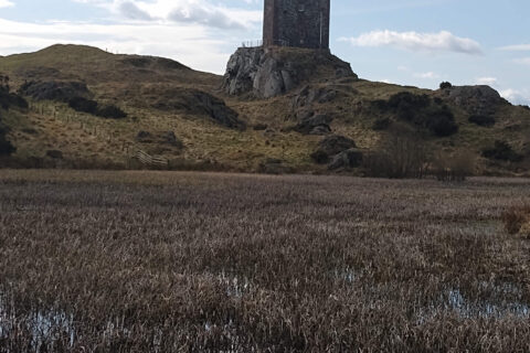

Stage 2
Take a diversion from the track to the tower where you will be rewarded with views to the Cheviot and Eildon Hills. Retrace your steps to the track and turn left towards the Tower car park
Stage 3
Pass through the gate, following the track take the second gate on the right and in a short distance through the gate on the left to follow the field downhill to “Westfield”, on the B6361 (this was the blacksmith’s workshop until the mid 1960s).
Stage 4
Turn right at the road, continue for 300m and then turn left on a tarmac lane. (At this point you can stay on the main road and follow to Smailholm for a shorter walk) The lane passes to the rear of the cottages at the top of this road and then swings right between two barns and heads alongside fields. Again, please take care as you pass through a working farm and there may be moving vehicles or livestock.
Climb to the crest and a magnificent viewpoint offering panoramic views, south (Jedburgh), west (Eildons and Blackhill) and north (Lammermuir Hills).
Stage 5
Continue on the track downhill, which, at the lower end, becomes undefined, after passing the derelict farm building bear slightly right heading towards the corner of the plantation. On meeting the farm track turn right here and follow through the woodland.

Stage 6
At the top of this track you join the B6397 for some 400m then continue straight ahead bearing off the main road, onto the side road, signed towards Mellerstain House.
Begun in 1725 and finally completed in 1778, this grand stately home has a fascinating history and is of unique architectural interest; the result of a fruitful collaboration between the Baillie family and two of Scotland’s greatest architects, William Adam and his son Robert.
Stage 7
Approximately 100m before Mellerstain gateway (opposite Sawmill Kennels and Cattery), turn right on to a farmtrack. Continue for 1.3km until reaching the tarmac road where you turn right for 400m, passing over a small bridge, then for a further 50m before turning left on to a farm track (Spur Path).
Stage 8
At the top, pass through the gate and turn left. (The wooded area on your right is covered in wild garlic and yellow aconites in the spring and hosts a variety of wildlife throughout the year) Continue down the track to where it bears right, on to a stony section alongside a field. Here, looking eastwards, are stunning views over the Eden Water and to the Hundy Mundy ruins (originally built as a folly but now used as a natural burial site).
Stage 9
Follow the track around the field margins until it bears right, pass through the wooden gate and proceed along the farm track. (This section overgrows in the spring and early summer!) Pass through the double iron gates to meet the road (B6397).
Stage 10
Turn right onto the road and follow it past Smailholm Church. Turn left on to the B6361 and back to the village hall.